
Analyzing the Quad-State Tornado with weather forensics
During the Quad-State Tornado(es), debris was lofted up to 30,000 feet in the air, which is one of the highest debris signatures ever recorded, indicating an updraft capable of supporting significant (EF2+) to violent (EF4+) tornadoes. Damage signals were present in radar data as the storm approached Mayfield, KY, Princeton, KY, and Earlington to Bremen, KY. This continuous track of tornadic circulation recorded by radar throughout the storm lifecycle may indicate the longest tornado ever recorded, exceeding the length of the Tri-State Tornado that crossed from Missouri to Indiana in 1925.

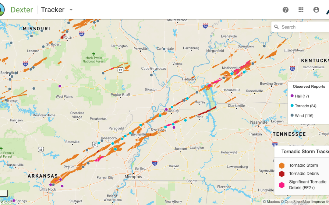
Athenium’s weather forensics shows significant debris near Mayfield, KY & EF2+ damage signatures near Madisonville.
The tornado damage assessment process
As of Monday, December 13, expert teams from NOAA are closely examining the tornado path, with wind damage experts analyzing the destruction to determine official damage ratings. These insights will help uncover whether this was a single, continuous tornado or a series of tornadoes across the region. However, this process is time-consuming – survey teams arrived on Monday, December 13, and it may take a week (or more) to complete the full assessment.
For those looking to better understand this event and its potential impacts on communities, property and infrastructure, the real-time event data is now available in our forensics tool, Dexter. Once the official surveys from the National Weather Service are complete, these will also be available in the dashboard by clicking the “Display EF-Scale Damage Rating” link at the bottom of the left-hand panel.
This data first entered our web dashboard at 8:40 PM Central Time on December 10, 2021, with hourly updates for the five hours that the supercell moved across Arkansas, Missouri and Tennessee. The full tornado was resolved by 1:40 AM Central Time on December 11, 2021. Since that time, the tornado forensics data has been quality-checked by our team to ensure it is ready for consumption at scale by our clients.
If you or your insureds were impacted by this event, please reach out for details on how to access our forensics data by emailing info@athenium.dreamhosters.com.
To learn more about our weather forensics solution for insurance carriers, please visit the Dexter page here.
On the horizon
On December 11, 2021, a storm chaser near Jonesboro, Arkansas snapped a photo of two tornadoes on the horizon. This phenomenon often occurs in tornadic supercellular thunderstorms as the atmospheric circulation for one storm dissipates and reforms further along the direction of storm motion. Athenium’s tornadic storm tracker (found in our weather forensics solution, Dexter) documented this slight “recycling” of the supercell, with the tornado track splitting across Interstate 555 southeast of Jonesboro while still showing two different rotation signals, at around 7 p.m. Central Time.
After this recycling event, however, the tornadic storm had a continuous path, crossing through parts of Arkansas, Missouri, Tennessee and Kentucky. This data, along with anecdotal storm chaser analysis, suggests that a single tornado could have remained on the ground for nearly 240 miles, with several observed tornado reports at various points along its path. If that proves to be the case, it would make the Quad-State Tornado a true outlier, with just a 1 in 10,000+ probability. In addition to the human-observed tornado observations, multiple radar signatures of tornadic debris and significant tornadic debris (EF2+) were present in Kentucky.
About the author
 Dr. Jonathan Fairman is the senior scientist of meteorology at Athenium Analytics. He’s an expert in atmospheric phenomena across all scales, from severe convective storms to global climate change. He leads development across all of the Athenium Analytics atmospheric products, with recent work on AtlasForecast and DexterTornado. Jonathan was born in Cleveland and holds BS and MS degrees in atmospheric science from The Ohio State University and a Ph.D. from The University of Alabama in Huntsville. He’s also a classically trained trumpet player and performs with ensembles throughout New England when he’s not thinking about the weather.