
June 1, 2021 – Today marks the official start of the Atlantic hurricane season – a busy (and often very expensive) time for insurers writing business along the Atlantic Coast and Gulf of Mexico. Last year produced a record-breaking 30 named storms, 11 of which made landfall in the U.S. According to Munich Re, these storms caused $43B in damages across North America, with insurers on the hook for more than 60% of that ($26B).
The National Hurricane Center (NHC) predicts that 2021 will be another above-average season, with an estimated 6 to 10 hurricanes and 3 to 5 major hurricanes. And just like last year, the 2021 hurricane season has already gotten off to an early start. There has already been one named storm ahead of the official season: Tropical Storm Ana, which formed north of Bermuda on May 22 and dissipated into the central Atlantic Ocean without any interactions with land.
Athenium Analytics has been hard at work throughout the offseason, enhancing our suite of hurricane response solutions built to help insurance carriers mitigate losses by providing 10-day forecasts, hyperlocal claims verification and curated email alerts to help triage resources. This year we’re pleased to announce several new updates to our hurricane forecasting and analytics suite, which are the most comprehensive enhancements to the BeaconHurricane product since it launched in 2016.
Enhancements to our proprietary 10-day hurricane forecast algorithm
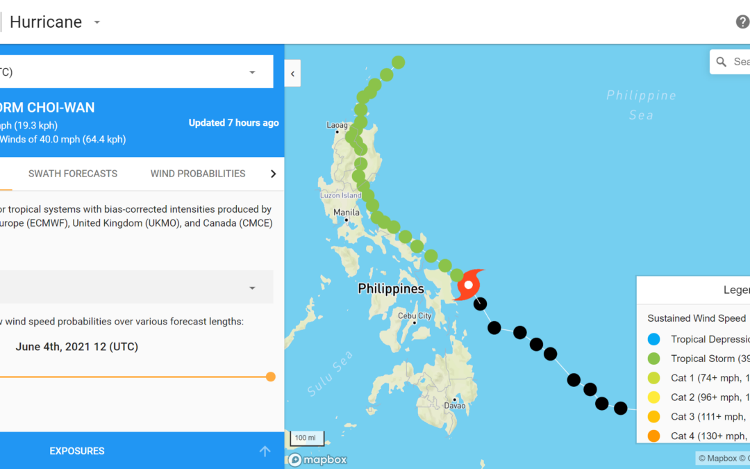
The most significant change this year is an update to our proprietary 10-day forecast algorithm. Since its release in 2016, the proprietary Athenium Analytics hurricane forecast relied on three different ensemble systems from national meteorological organizations. This year, we’ve not only included additional models from NOAA, but also added a brand-new input: the United Kingdom MetOffice global ensemble system. The addition of MetOffice data brings our total number of individual ensembles up to 141. These unique ensemble members provide a wide range of possibilities and we take them all into consideration with our dynamic forecast blend.

The United Kingdom MetOffice ensemble mean track for Tropical Storm Yaas.
Overall, these updates yield a 10% improvement in our tropical cyclone track forecasts (as measured by overall error reduction). These benefits extend throughout our forecasts as well, leading to more accurate information at longer lead times, which is especially useful for insurers when NHC information is not yet available.

Athenium Analytics forecast track improvements, assessed over the 2020 season.
Other key hurricane analytics updates
In addition to the forecast updates, other offseason improvements to our hurricane analytics suite include:
- A significant scientific update to our swath generation algorithm, which now takes a dynamic, latitude-based approach to calculating the areal extent of a storm. This improves our ability to predict how far storm impacts will reach and make better estimates about which insured’s locations will be affected.
- A transition from 6-hour to 3-hour forecast data, which provides clients with higher resolution insight into timing for key details (landfall, changes in storm path, etc.) of storms.
- Display of ensemble mean tracks from our source models, giving many realistic options of where the storm may proceed.
- Many other tweaks to our proprietary hurricane track forecast. We tested our updated forecast algorithm against the entire 2020 hurricane season over 40 times to ensure statistical consistency and confirm the quality of the improvements.
Collectively, these updates are designed to provide powerful, timely and actionable insights into each storm.

Athenium Analytics 3-hour data output for Hurricane Irma.
BeaconHurricane Alerts
Athenium Analytics meteorologists will continue to provide curated BeaconHurricane Alerts throughout the 2021 season. The email alerts are hand-crafted by our team to provide the exact information insurers need to make business decisions about impending tropical systems. Each alert is written by a team of scientists and includes the most up-to-date forecast insights. Alerts will be delivered at 9:30am and 6pm ET throughout the season.
BeaconHurricane alert emails are free for Athenium clients and members of the insurance community. Click here to sign up for this season’s alerts.
BeaconHurricane Exposure Reports
Athenium Analytics clients of the Beacon product are also able to opt into BeaconHurricane Exposure Reports, which provide a customized insights into any exposures that fall within a storm’s forecasted path. These reports can be modified to meet the needs of the insurer, including the ability to select storm intensity thresholds and the report frequency. These Exposure Reports were introduced last season, and we received glowing feedback from clients about their value for understanding potential impacts ahead of a storm.
Hurricane season can be unpredictable, but the hurricane suite from Athenium Analytics is ready to provide powerful, actionable insights throughout the 2021 hurricane season. Current clients are encouraged to reach out directly to their account manager with any questions.
If you’re interested in learning more about our hurricane response tools for insurance, visit this page to request more information now.